
MA Umi Projects
Latest works of Valerie Portefaix | MA Umi (Ishigaki)

FROM YAEYAMA TO OKINAWA :
HOW CLOSE DO YOU FEEL US?
Curated and produced by Valérie Portefaix | MA Umi - Ishigaki Archives 1955 with works by Yasuo Kabira, Kimiko Matsutake, Hideo Motohara, Valérie Portefaix, Setsuko Yamazato - Sakimac Art Museum, Okinawa, 2026
From the southern archipelago, colors rise from ground and sea — red, yellow, blue — carried by stone and thread across space. Waves repeat, weaving holds, formations gesture — like the geological markers that shape the Yaeyama. Across distance, the islands speak in rhythm, in weight, in presence—through the patterns of weaving, the layering of stones, and the echoes of song and dance. Across space, they endure — dispersed, persistent, alive — relation without center, without surrender.
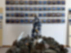
The exhibition centers on valuable materials and maps from military geological surveys conducted between 1955 and 1957 by Dr. Helen Foster, a geologist with the U.S. Geological Survey, with the assistance of the young Setsuko Yamazato. Born on Ishigaki Island in 1937, Yamazato san experienced profound loss during the Battle of Okinawa, when four members of her family were killed. In the postwar years, she drew on English skills acquired at the U.S. Civil Administration’s Ryukyu-American Cultural Center to advocate for and promote local culture.
Two decades later, she came to understand that surveys she had supported on Ishigaki Island had in fact served military objectives—an awareness that shaped a lasting sense of responsibility. Grounded in these experiences, Yamazato san has since been actively engaged in peace movements. In 2016, committed to ensuring that the Yaeyama region is never again transformed into a site of conflict, she founded “Grandmothers Protecting Life and Livelihood,” a grassroots initiative opposing the deployment of the Ground Self-Defense Force and the construction of a missile base on Ishigaki Island, and organizing sustained weekly protests.
Through the mineral traces and pigments embedded in the works of Kiyoko Matsutake san—renowned for her expertise in Yaeyama Jōfu and Shiraho-ori textiles—the island’s vivid landscapes are rearticulated in material form within the museum space. Drawn to the chromatic richness of Ishigaki’s terrain, Hideo Motohara has produced works that examine the island’s jungles and wartime cave shelters, echoing the visual and emotional registers found in the epic scenes of the Battle of Okinawa at the Sakima Art Museum.
CRUSHING TIME
Curated by Valérie Portefaix - Co-author of the project, archives and film Running Against the Wind with Setsuko Yamazato - Ishigaki City Library, 2025
Crushing Time: Ishigaki Geological Stories unveils the island’s geological memory through rare color 16mm film, photographs, and maps from pioneering geologist Helen Foster. This material, part of the Setsuko Yamazato’s archive, was entrusted to her by Helen in 2000. In 1955-56, at just 17 years old, Setsuko served as a young assistant for the American geological survey of Ishigaki. The maps, created in Tokyo between 1957-59, later served as the basis for a military geology survey of Ishigaki, now kept in Washington.
Today, the island’s coastal landscapes are rapidly vanishing due to overdevelopment—raw stones and other materials are crushed, jungles are cleared, and ecological histories are erased. The exhibition confronts this transformation, juxtaposing archival imagery with new maps and sculptures that reimagine the island’s lost terrains. The spectral figure of Majimunu, emerging from the past, weaves through these landscapes, embodying resistance and memory within the shifting topography of Ishigaki.

25°46′N - 123°31′E
Valerie Portefaix | MA Umi, 25°46′N - 123°31′E, ARTNaha, Naha, Okinawa, 2022
It’s a rich fishing ground. The island is currently home to domestic goats and albatross. An endemic species of mole is also taking refuge on its rocking shores. Hermit crabs disperse the seeds around and fertilise the seabed. It is a fragile dynamic system that demands protection. Among the noise of territorial conflicts, the sea is also suffering. And if it had a voice, what would it say?
25°46′N - 123°31′E is a research project advocating for the protection of the sea, and thus is reclaiming the island and its ocean territory for our common humanity. This claim is made on the basis that human activities are harming the globally significant biological diversity.
For this iteration of the research, a colony of hermit crabs are the voices of a new oceans narrative. They carry messages that help us to rethink climate change and environmental justice by focusing on the non human nature of the islands.
Viewers are witnessing a research process in which map making is comparable to a process of constructing a narrative or of writing calligraphy.
For the ARTNaha exhibition curated by Hitomi Hasegawa and Naoko Uchima, the installation is divided into two sections: one addressing the complexity of the ocean and the fluctuating forces that shape its currents, living organisms and the seabed; and the other expressing the potential empathy carried by the hermit crabs filmed while traversing various contextual situations: the seashore, a shrine and a model of the island in the shape of a ghost island made of lost fishing nets drifted to the beach of Ishigaki.
MAP Office Archives
Latest works of MAP Office (Hong Kong) with Laurent Gutierrez

GHOST ISLAND
MAP Office, Ghost Island, Thailand Biennale, Krabi, 2018
Ghost Island is a large installation comprising numerous fishing activities, invisible stories and multiple cultures. Shaped in the form of an island made of a complex assemblage of bamboos, it is formed by the accumulation and stratification of numerous distinct layers of disused fishing nets. In this way the main material used for the construction of the new island will be free and help cleaning up the sea.

THE MAKING OF GHOST ISLAND
MAP Office, The Making of Ghost Island, Thailand Biennale, Krabi, 2018
Ghost Island is made of a complex assemblage of bamboos, cut, laminated and assembled by a team of Thai, Malay and Burmese killed workers. It was completed with the accumulation and stratification of numerous distinct layers of lost fishing nets, about two tones rescued from the coral reef in the archipelago.

THE ARCHEALOGY OF DIVING
MAP Office, The Archaeology of Diving, Milan Triennale, Milan, 2018
The Archaeology of Diving was recorded around Toba City, in the Bay of Ise in central Japan, in August 2018. The film portrays the timeline of the unique way of life and the free-diving practice of a small group of divers from multiple generations. It begins as they come together in the amagoya, a simple hut located on the seashore, where they warm up, repair and store their diving gear, and share food and stories.

THE POLITICS OF DIVING
MAP Office, The Politics of Diving, Milan Triennale, Milan, 2018
During a series of trips to JeJu Island (Korea) and Shima (Mie Prefecture, Japan), we have encountered incredible figures, ama- san and haenyeo, with unique stories meeting multiple issues of MAP Office research on seaweed, subsistence economy, coastal ecology, matriarchal society, anarchy, nomadic life. In Goza, Yamashita-san gathered her tools to compose “A glossary of her world”. She presented different types of diving gogles, explaining the differences and reasons why she has been using the same mask for last 30 years.

THE STORY OF AMANAMI
MAP Office, The Story of Amanami, Milan Triennale, Milan, 2018
Composed across artefacts, performance, photography, drawing and interview, The Story of Amanami is a contemporary expression of the ama divers’ history, culture and tradition around the Bay of Ise, in Japan. Amas have been a typical subject for artists and capturing their exotic beauty as sea creatures and their unique culture uncontaminated by the different processes of modernity. The main component of the project is a drawing installation that reimagines the ukiyo-e – not as technique – but as an accurate ethnographic representation of the coastal landscape during the edo period. This complete cycle between the body of the performer and the territory defines a stable ecology and economy of the coastline.

THE BOOK OF WAVES
MAP Office, The Book of Waves, PF25, Basel, 2018
Inspired by Kyoto artist Mori Yuzan, The Book of Waves propose an animated selection of waves and ripples from ancient representations of sea movement. The hand-drawn animation fills the gap between drawings to propose new relations and flows between the various ocean conditions. Water currents and turbulence at sea exemplify today the effects of climate change, sea level rise, and increasingly more violent typhoons.

ISLAND
RESORT
MAP Office, Island Resort, Yokohama Triennale, 2017
Island Resort consists of over 200 islands, conducts extensive research and fieldwork on islands, territories and territorial waters, and applies it to interdisciplinary artistic endeavors. Here, they present an installation in the Grand Gallery of the Yokohama Museum of Art in which works are arranged like islands in an archipelago. In their new work representing the image of the island country Japan as a soundscape, the ambiguities inherent in the island paradigm can be heard in fragments taken from Japanese literature and movies assembled according to the concepts “time,” “war,” “love,” “fantasy,” and “elsewhere.” In addition, they present 11 works from seven series for the first time ever in Japan, including The Coral Island, addressing the severity of humans’ destruction of the natural environment; Liquid Land, Solid Sea, which has removed all names of nations and any kinds of proper nouns from the map of the South China Sea where a lot of territorial and right disputes are occuring ; and Island For The Colorblind, inspired by the Ishihara color vision test, in which they arranged green and pink sea urchin shells on a circular table to create numerals, exploring the possibility or impossibility of communication and the uncertainty of boundaries and territory.

ISLAND
FOR THE
COLORBLIND
MAP Office, Island For The Colorblind, 2014
Pink and green sea urchin shells (about 3000 pieces - origin Greece, Crete)
Island For The Colorblind is a territory that cannot be seen by everyone. Inspired by the Ishihara color test, the figure 69 is embedded in the landscape as a number of pink and green urchin shells. The deliberate choice to portray the number 69 has multiple reasons, ranging from the optical agility this number incorporates, to the symbiosis of two entwined figures. The island is exclusive and possibly invisible to some.

JAPANESE ARCHIPELAGO
MAP Office, Japanese Archipelago, Yokohama Triennale, 2017
Our approach of the Japanese Archipelago is through literature and cinema. The role played by islands in Japanese culture goes beyond the simple idea of being isolated. Obviously the islands have served as places of love, fantasy, survival, detention, mythologies, war, etc.

DESERT ISLAND
MAP Office, Desert Island, Singapore Biennale, 2016
In the Anthropocene, the history of the 21st century will be written on water. With sea level on the rise, the ocean has become both the new frontier and the last space, to be either uncovered for the benefit of humankind or condemned as the locus of its final demise. They have long played a major role in nourishing the imagination and establishing new points of reference in defining the world. The map of Desert Island presents the ocean as an imaginary world of islands, each informed by literary tales, narratives, and statistics.

SOUTH
CHINA
SEA
MONUMENT
MAP Office, South China Sea Monument, Eflux, 2020 > LINK
A project developed with maritime lawyer Agnes Chong and geologist Eric Laflamme.
“South China Sea Monument” is a research on current discussion in the South China Sea. What seems to be solely referring to international law and ancient treaties signed by a few nations is in reality a complex territory made of islands and shoals that are barely emerging above the sea. At this point, geography is in the hand of signed papers that are defining the current ecology and economy of the region, as well as shaping future geo-political activities of the neighbouring countries and beyond. We are setting up - using the law with maps, drawings and texts, the idea that the High Seas as a “natural special maritime zone” in the South China Sea could be carved for the common heritage of mankind that is free of any single sovereign control. The environmental protection is crucial for the conservation and sustainability of marine biological diversity of the High Seas.